Theme images by kelvinjay. Powered by Blogger.

USA

AFRICA

ASIA

Brazil

Portugal

United Kingdom

Switzerland

French archaeologists restore three Sudanese artefacts


A team of French diggers has restored three Sudanese artefacts, including a 3,500-year-old wall relief, and handed them to the African country's national museum on Thursday, a French archaeologist said.

French archaeologists restore three Sudanese artefacts
A visitor looks at a wall relief inscription, discovered at the temple of Soleb, on display
at the Sudan National Museum [Credit: Ebrahim Hamid/AFP]
The three artefacts were discovered at separate archaeological sites in recent years in Sudan and were restored by a French team of experts.


The items are a wall painting of an ancient Kandaka Nubian queen, a Meroite stela and a wall relief inscription believed to be almost 3,500 years old.

French archaeologists restore three Sudanese artefacts
Marc Maillot, director of the French archaeological unit in Sudan, stands next to an ancient wall painting
displayed at the National Museum of Sudan in Khartoum [Credit: Ebrahim Hamid/AFP]
"The idea is to give back to the museum the most important archaeological pieces discovered and restored," said Marc Maillot, director of the French archaeological unit deployed in Sudan.


The wall painting was found at El-Hassa site, the stela discovered at Sedeinga and the relief at the temple of Soleb, where French diggers along with Sudanese counterparts have conducted extensive archaeological work for several years.

French archaeologists restore three Sudanese artefacts
A stela, discovered at Sedeinga pyramids, is displayed at the National Museum
of Sudan in Khartoum [Credit: Ebrahim Hamid/AFP]
On Thursday the three artefacts were handed over to the Sudan National Museum to mark the completion of 50 years of French archaeologists' presence in the country.

For decades international archaeologists have worked extensively in Sudan, proving that the northeast African nation has its own extensive wealth of ancient relics and was not merely a satellite of neighbouring Egypt.

Archaeologists are convinced that many kingdoms still lie buried, waiting to be discovered.

Source: AFP [September 19, 2019]

'Ancient Nubia Now' at the Ann and Graham Gund Gallery, Boston


Between 2500 BCE and 300 CE, a series of kingdoms flourished in what is today the Sudanese Nile Valley, a region known in antiquity as Kush and by modern scholars as Nubia. Ruling from the capitals of Kerma (2400–1550 BCE), Napata (800–300 BCE), and Meroe (300 BCE–300 CE), Nubian kings and queens controlled vast empires and trade networks, rivalling—and even for a brief time conquering—their more famous neighbors, the Egyptians.

'Ancient Nubia Now' at the Ann and Graham Gund Gallery, Boston
Winged Isis gold pectoral, Nubian, Napatan Period, reign of Amaninatakelebte, 538–519 BCE
[Credit: Harvard University–Boston Museum of Fine Arts Expedition]
The Nubians left behind the remains of cities, temples, palaces, and pyramids, and their artists and craftspeople produced magnificent jewelry, pottery, metalwork, furniture, and sculpture. Yet today many people are unaware that these great civilizations even existed.


The Museum of Fine Arts played a key role in bringing ancient Nubia to light, undertaking excavations at ancient Nubian sites in southern Egypt and northern Sudan between 1910 and 1930. As a result, the MFA’s collection of ancient Nubian art is the largest and most important outside Khartoum, and represents a major resource for scholars of ancient Nubia today.

'Ancient Nubia Now' at the Ann and Graham Gund Gallery, Boston
Granite statue of King Senkamanisken, Nubian, Napatan Period, reign of Senkamanisken, 643–623 BCE
[Credit: Harvard University—Boston Museum of Fine Arts Expedition]
Ancient Nubia Now features more than 400 highlights from the collection, many never before exhibited. Among the highlights are the exquisite jewels of Nubia’s queens, the nearly lifesize statue of Senkamanisken from the sacred mountain of Gebel Barkal, the army of funerary figurines from the tomb of King Taharqa, the gold and silver treasure of King Aspelta, and the stele of King Tanyidamani, bearing the longest known inscription in the still untranslated Meroitic language and script.


Precious objects imported from Egypt and the Mediterranean world shed light on Nubia’s role as a leader in foreign commerce. Along with introducing visitors to the breadth, innovation and technical mastery of Nubian art, Ancient Nubia Now explores the reasons for which Nubia remains unfamiliar to most Americans, including a shortage of written documentation from antiquity, the prejudices of early excavators, and propaganda from its neighbor and rival Egypt.

'Ancient Nubia Now' at the Ann and Graham Gund Gallery, Boston
Sandstone block from a coffin bench, Nubian, Meroitic Period, early 2nd century BCE. Findspot: Sudan, Meroe,
Pyramid Beg. N. 8, burial chamber [Credit: Harvard University - Boston Museum of Fine Arts Expedition]
At the Ann and Graham Gund Gallery (Gallery LG31), from October 13, 2019 til January 20, 2020.

Source: Museum of Fine Arts, Boston [August 20, 2019]

Layout of historic Nubian city revealed


Polish archaeologists have gained an insight into the 18th century layout of an old city in what is now Sudan using geophysical research.

Layout of historic Nubian city revealed
Given the site’s size, archaeologists were unable to examine all of it using traditional excavation methods so turned
to geophysical methods, which involve using quantitative methods to analyse physical processes
and properties of the Earth [Credit: S. Lenarczyk]
Located on the east of bank of the Nile, Old Dongola was the capital of Makuria, a Nubian kingdom that existed in what is now Northern Sudan and Southern Egypt from the 6th to the 15th century.


A Polish archaeological mission from the University of Warsaw’s Centre for Mediterranean Archaeology has been working in Old Dongola since 1964.

Layout of historic Nubian city revealed
A Polish archaeological mission from the University of Warsaw’s Centre for Mediterranean Archaeology
has been working in Old Dongola since 1964 [Credit: PCMA UW (CAS UW)]
In 2017, the team led by Dr Artur Obłuski received a European Research Council for a project entitled “UMMA: Urban Metamorphosis of the community of a Medieval African Capital City”.


Now the archaeologists have shown that the city outlasted the change in power, surviving until the early 19th century, when it fell suddenly, reports Science in Poland (Nauke w Polsce).

Layout of historic Nubian city revealed
Fieldwork in Old Dongola [Credit: M. Reklajtis/PCMA UW (CAS UW)]
Given the site’s size, the archaeologists were unable to examine all of it using traditional excavation methods. Instead, they turned to geophysical methods, which involve using quantitative methods to analyse physical processes and properties of the Earth.


The geophysical research, encompassing magnetic and ground-penetrating radar methods, was carried out by Tomasz Herbich and Robert Ryndziewicz, experts at the Polish Academy of Sciences’ Institute of Archaeology and Ethnography. The resulting images showed the city’s layout shortly before its downfall.

Layout of historic Nubian city revealed
A citadel and adjacent area with a mosque, which before 1316 was a throne room
[Credit: S. Lenarczyk]
“Based on my preliminary search, it appears that we do not have such data for any other city from this period in Africa,” said Obłuski.


The geophysical research also showed that the city’s walls changed function over time. Initially, they served to protect the city; later, they separated different districts from each other.

Layout of historic Nubian city revealed
Excavations in Dongola reveal remains of 18th-century housing
[Credit: M. Reklajtis/CAS UW]
In addition to geophysical methods, the archaeologists conducted a broad survey of excavations, covering almost half a hectare over the past season. Their findings suggest that the city’s residents had a relatively high standard of living – as suggested by ceramics from Japan and pipes found on site.

“Interestingly, in the 18th Century Dongola’s inhabitants were probably heavy smokers. We found a few pipes in every house, and tobacco was not a cheap good at the time,” Obłuski observed.

Author: Anne Chatham | Source: The First News [July 11, 2019]

Ancient artefacts, rock art discovered in Sudan


Julien Cooper loves exploring places on the periphery. From hiking in his native Australia to trips to remote locations throughout Europe with his family, Cooper, a postdoctoral research associate in Yale’s Department of Near Eastern Languages & Civilizations, has always enjoyed going to locations for the sole purpose of being off the beaten track.

Ancient artefacts, rock art discovered in Sudan
A Yale-led team of archaeologists discovered a wealth of archaeological finds in a remote desert in the
 Republic of Sudan, much of which were created by an ancient indigenous nomadic population
[Credit: Yale University]
Even the ancient cultures that he studies are from far-flung areas — the remote desert in the Republic of Sudan. Cooper led an archaeological expedition there to further his research about the Egyptian pharaonic civilization, particularly how the ancient pharaohs and various civilizations in ancient Egypt and Sudan obtained gold from this distant desert. The team also wanted to assess antiquities threatened by goldmining. This trip marked the first time that Cooper served as director of an international mission.

“The study of these cultures combines two of my passions: archaeology and being in the middle of nowhere,” says Cooper.

The six-person expedition of Sudanese, Australian, British, and Swiss researchers to the Sudanese desert east of the Nile was three weeks long and covered about 1,250 miles — “about as long you can go in the desert,” says Cooper. The team camped at 10 sites over the course of 14 days.


The archaeologists undertook their expedition to the eastern desert of Sudan with the intention of researching the ancient nomads of the region and also assessing antiquities threatened by goldmining. Due to the nature of the itinerary, each site was only visited briefly, with a short amount of time to take measurements and photographs and sometimes sketches. No excavations were undertaken.

Travel in this desert had its challenges, says Cooper. “There were no roads, so we drove through sand in an all-terrain vehicle. There were very few local water sources and no villages to obtain more gas to fuel the cars. We constantly monitored our supplies to make sure we had enough to get back to the Nile River.

“Digging our four-wheel-drive out of the sand was an almost daily occurrence,” he adds.

Ancient artefacts, rock art discovered in Sudan
The team of archaeologists — led by Julien Cooper, a postdoctoral research associate in Yale’s Department
of Near Eastern Languages & Civilizations — were intrigued at the sight of trees in the desert
[Credit: Yale University]
Still, he says, the trip was well worth the struggle. What Cooper and his team’s exploration revealed was that this remote Sudanese desert was rife with discoveries about the area’s ancient, and modern, denizens.

“There is a wealth of archaeological finds in this desert,” says Cooper, much of which were created by an ancient indigenous nomadic population. “Ancient texts call these people the ‘Medjay’ or the ‘Blemmyes.’” These nomads are well known in Egyptian and classical texts as nomads of the Eastern Desert, who frequently came to the Nile to trade, raid, and seek employment in Egypt. In distant medieval Europe they were infamously depicted as grotesque headless beings who raided monastic settlements in Egypt.

Cooper and his colleagues considered themselves lucky to find two or three new sites. “Most expeditions are excavating and recording sites well known to scholarship, and they’re hoping to find out more about that site, whereas our mission this year is a bit unique in the sense that we want to find new sites.”


To find the sites, Cooper and his team relied on satellite photographs and an archival report Cooper found that detailed a trip taken by archaeologists in 1930. The team also used a GPS and satellite photos to identify some sites, while others “we just stumbled across,” says Cooper, like the time they found a rock art tableau with a depiction of a fleet of boats, about 13 in total — an unexpected discovery for the archaeologists, and one of the southernmost examples of this kind of rock art, which dates from the earliest periods of Egyptian civilization (c. 3500-3000 BCE).

“There is ritual symbolism behind the portrayal of boats in the desert,” says Cooper, explaining that the illustration of a boat was akin to depicting home for the ancient Egyptians, who would use boats like those depicted to traverse the Nile River.

Cooper, who came to Yale in 2018, says that he and his colleagues were able to determine that this desert was much more important to the Egyptians than was previously thought. Cooper explains that trade-routes crisscross the desert, and the region must have been much been a key conduit for various goods, notably gold.

Ancient artefacts, rock art discovered in Sudan
These images of boats occur often in Egypt but this is one of the southernmost examples of it. This was is a very important
find for the archaeologists because it showed how Egyptians were using all of the trade routes in the desert
[Credit: Yale University]
“What this discovery [of Egyptian art] is telling us is that ancient Egyptians and other ancient Nubian cultures were using the trade routes in the desert with a lot more regularity than previously believed. This finding changes our understanding of the foreign imperialism in this desert. The ancient Egyptians moved into this desert, which was inhabited by foreign nomads, to mine gold as well as trade with nomads. They then used the gold to make various objects and, more famously, statues and other royal regalia.”

The team also recorded an ancient gold mine and a large cemetery with disk-shaped tombs. On one tomb a number of fertility figurines were found lying on the surface. “We are one of only two other missions that have ever found these figurines,” says Cooper. “Recording the gold mine was really interesting, as the distinct type of local pottery suggested the mining settlement was dominated by local nomads rather than foreigners.

The team was amazed at how many sites you could locate if you just went over one hill or explored a new valley. “The reason for the rich archaeology in this region is that the desert is so dry and it keeps all of these sites intact on the surface. And while we don’t have leftovers of organic remains, we have all of these surface artifacts, rock-art, gold mines, and cemeteries with hundreds of tombs,” says Cooper.


The archaeologists were also intrigued at the sight of trees in the desert. “This isn’t an average desert. It is much more mountainous and a higher elevation than the average, so gets a bit of mist and rainfall every now and then, both of which makes it not quite as hyper-arid as you would expect elsewhere in the large Sahara Desert,” says Cooper.

One of the biggest revelations for Cooper and his fellow archaeologists was the collegiality that they encountered even in this remote location. “When you’re in the desert you feel like you’re all part of one society because of the harshness of the area,” says Cooper. “Whether you’re a goldminer, a nomad, or a Yale archaeologist, you all try to help one another.”

On one occasion the team came across a gold miner whose car had crashed and overturned — leaving him stranded, dehydrated, and in need of water for his radiator. Cooper and his team shared some of their spare water with him. Another time it was Cooper’s team that needed help. “We had too many flat tires, and one of our spares didn’t work. We came across a lorry run by local nomads, which had an air pump on the back of it. In the back of the lorry were kids, livestock, and chickens. These nomads were happy to stop on the mountain pass for almost an hour to pump up all of our tires,” says Cooper.

Ancient artefacts, rock art discovered in Sudan
Julien Cooper [Credit: Yale University]
“It’s a fascinating thing for me to see and experience because you don’t always get that kind of neighborly support in western societies. The nomads would show us new parts to a site we were exploring,” he notes. “I feel like the desert is a special place because everyone does help each other, partly because you’re so far away from the relative comfort of the Nile. Even if it means losing three or four hours — or even a day — of work, you look after one another.”


Cooper, who estimates that he and his team probably discovered only one-tenth of what can be found in this area of the desert, is looking forward to leading the next sojourn at the end of this year.

Travelling through much of the desert allowed the team to make a brief assessment of the risk that these sites and this desert face from modern goldmining, which in some cases has resulted in destruction of archaeological remains. Particularly at risk, says Cooper, are the vestiges of ancient goldmining itself, namely the ancient miner’s huts and the geological remains of goldworkings.

“One of the reasons I want to go into this desert is to preserve its heritage while it still exists. Sudan is experiencing a goldmining boom, which has the potential to destroy the cultural heritage that exists there. The way forward is collaboration between the gold miners and archaeologists,” says Cooper.

Author: Bess Connolly | Source: Yale University [May 11, 2019]

Possible migration route of Homo erectus from Africa discovered


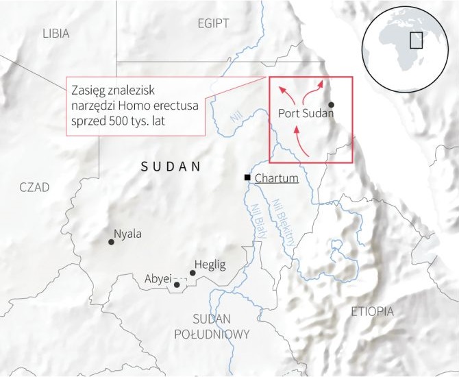
In the Eastern Desert in Sudan, Polish archaeologists have found 500,000 years old traces of the presence of Homo erectus. According to the discoverers, it is a proof of existence of an unknown migration route of this species beyond the continent.

Possible migration route of Homo erectus from Africa discovered
Credit: Maciej Jordeczka
The African variety of Homo erectus (upright man) - the ancestor of modern man (Homo sapiens) - appeared in Africa about 1.8 million years ago, from where it quickly migrated to Eurasia. These migrations took place in stages.


Eastern Africa is considered the cradle of humanity. The oldest traces of human activity in the form of stone tools have been discovered along the Great Rift Valley, which stretches from Mozambique through Tanzania to the coast of the Red Sea in the region of Eritrea and Ethiopia. In terms of research on the oldest traces of man, the area farther to the north of Africa - the Eastern Desert in Sudan - is somewhat forgotten. Polish archaeologists decided to focus on this area. The project funded by the National Science Centre involves scientists from Saudi Arabia, South Korea, Germany and the US.

Possible migration route of Homo erectus from Africa discovered
Credit: Marcin Szmit
Possible migration route of Homo erectus from Africa discovered
Credit: Miroslaw Masojc
Possible migration route of Homo erectus from Africa discovered
Credit: Miroslaw Masojc
"We have found 500,000 years old traces of the presence of Homo erectus - a total of more than a thousand stone products including characteristic hand axes, which proves the existence of a previously unknown migration route of this species beyond the African continent, probably along Red Sea coasts", says the research project leader Prof. Miroslaw Masojc from the Institute of Archaeology, University of Wroclaw. He adds that these are by far the oldest traces of human presence in this part of North-East Africa.


Up to now, the prevailing views were that H. erectus moved north mainly along the Nile Valley. The researcher adds that although today the study area is a flat and inhospitable desert, hundreds of thousands of years ago there were periods of a much more humid climate. There was vegetation and rivers - their dried beds indicate the course towards the north-east, towards the Red Sea.

Possible migration route of Homo erectus from Africa discovered
Credit: Maciej Jordeczka
Possible migration route of Homo erectus from Africa discovered
Credit: Maciej Jordeczka
Discoveries in the Eastern Desert also confirm the long coexistence of Homo erectus with Homo sapiens in Africa: it is a period of at least 100,000. years, between 300,000 and 200,000 years ago. Both species lived there simultaneously, although one gave birth to the other.


The discovery of over half a million years old stone tools was made accidentally in recent years. "There was a gold rush in the eastern part of Sudan, in the Eastern Desert, as in many places in the Sahara - people looking for this precious metal in makeshift, open-cast mines. By uncovering successive layers, miners came across tools from several hundred thousand years ago", says Prof. Masojc.

Alerted by reports of unusual finds, archaeologists set out into the field. "We work in the mines after miners have already left them, so there is no conflict of interest", the scientist adds.

Possible migration route of Homo erectus from Africa discovered
Credit: Miroslaw Masojc/PAP
So far, researchers have found almost 200 places where Palaeolithic stone products have been preserved. Some of them are located in mines, about 350 km north of Khartoum. The archaeologists find various tools used both by Homo erectus - hand axes and pebble tools, and by Homo sapiens - for example blades. Ancient people used mainly quartzite and volcanic rocks. The age of the tools ranges from more than half a million to 60,000 years. "It would not be possible to find these traces without mining operations", the archaeologist says.

The first results of the project have just been published in the Journal of Human Evolution.

Additional information about the project can be found at: http://sudan.archeo.uni.wroc.pl/

Author: Szymon Zdzieblowski | Source: PAP - Science in Poland [May 08, 2019]

A mighty Egyptian fortress revealed


Since he and his team began excavating the ancient Egyptian colony of Tombos in Sudanese Nubia, Stuart Tyson Smith has made a host of discoveries. But something eluded the UC Santa Barbara professor of anthropology: evidence of the fortifications typical of a settlement on the frontier.

A mighty Egyptian fortress revealed
A head from a woman's coffin dating to the 18th Dynasty, roughly 1400 BC. 
It came from tomb near Tombos [Credit: Stuart Tyson Smith/UCSB]
No longer. In a chapter of a new book, From Microcosm to Macrocosm: Individual households and cities in Ancient Egypt and Nubia (Sidestone Press, 2018), Smith and his co-author, Michele Buzon, a professor of anthropology at Purdue University, detail their discovery of the foundations of a fortress at Tombos that likely dates to the colony’s founding around 1450 BC.


The discovery of massive fortifications — 400 meters a side — helps cement Tombos’ place as an important Egyptian colony of the New Kingdom (c. 1550-1070 BC), said Smith, who has excavated the site in Sudan with Buzon since 2000.

“Karoy was a lost fortress — nobody knew exactly where it was and the likely candidates all had other names,” Smith said. “Once we started excavating in the cemetery people started speculating that it might be at Tombos, but there was no sign of a fort. It was puzzling, because it didn’t fit the bill; it was explicitly called a fortress, so it had to be fortified. Once we found a fortification, I went, ‘Aha! Here’s the smoking gun that lets us know that this is the place mentioned by the Vizier Merymose over 3,300 years ago at the edge of the colonized zone of Nubia.’ ”

A mighty Egyptian fortress revealed
UCSB alum Mohamed Faroug Abdelrahman Ali, who supervised the town excavation in Tombos,
 stands in a dry moat, part of an ancient fortification [Credit: Stuart Tyson Smith/UCSB]
In “The Fortified Settlement at Tombos and Egyptian Colonial Strategy in New Kingdom Nubia,” Smith and Buzon write that the first hints of a fortress at Tombos date to the first years of the 16th century BC, when the pharaoh Thutmose I conquered Kush and incorporated Nubia into an empire that would last through the end of the New Kingdom.

Not long after, Thutmose I ordered inscriptions carved on granite outcrops at Tombos, which Smith and others have argued signified an internal boundary within Egypt’s Nubian empire at the headwaters of the Third Cataract. Interpreters of the inscription have said it refers to the construction of a menenu, or fortress, at the site — although no fortification had been found.

Fast-forward more than 3,500 years. Beginning in 2013 and continuing through the 2015-17 field seasons at Tombos, Smith and Buzon discovered evidence of buildings and what they termed “a massive new fortification.” Distinctive pottery types, inscriptions and radiocarbon dates indicate that it was built around 50 years after the conquest, probably commissioned under the joint reign of Queen Hatshepsut and her stepson Thutmose III (c. 1578-1458 BC).

A mighty Egyptian fortress revealed
Inscriptions carved into granite outcroppings at the Third Cataract of the Nile. They're about 100 yards north
of the Tombos fortress and commemorate Thutmose I's conquest of the Kingdom of Kush in 1502 BC
[Credit: Stuart Tyson Smith/UCSB]
“One of our goals was to find the town where people were living,” Smith said. “We knew it was somewhere under the (modern) village because we’ve seen pottery and we’ve done a couple of little tests and found some foundations in one spot, a bunch of pottery in other places. And so we decided to go all in and just start digging in every open space the villagers would let us dig in. And they were very nice about it, which I have to say is typical of the Nubian people who have been our hosts all these years.


“Initially, we found this weird feature,” he continued. “It looked like a subterranean building of some kind.” Below ground, it was a trench lined with mud brick walls and had mud floors on a stone foundation. It was also filled with “heaps and heaps of pottery, so there were a lot of people living nearby.”

Smith and Buzon weren’t sure what it was, but in the next two seasons they kept following it in both directions. They dug a number of test trenches to see how far it went through the village. “It just kept going and going,” said Smith, noting it ran far past the southern edge of the modern village and out to the Nile to the west, a span of more than 200 meters to a side. It is, he said, larger than any of the other fortified colonies going back to the Middle Kingdom (c. 2050-1710 BC).

A mighty Egyptian fortress revealed
This heart scarab from the tomb of a woman named Weret, was inscribed with a spell from the Book of the Dead that
prevented a person's heart from testifying against them in the divine judgement. A scarab with a person's
head is rarer than the purely insect type [Credit: Elizabeth Drolet/UCSB]
Why such a big fortress at Tombos? Buttressing the newly discovered importance of the site, Smith said, was the earlier discovery of an elaborate tomb for an Egyptian official named Siamun. Originally arrayed across the façade of the tomb were funereal cones referring to him as “scribe-reckoner of the gold of Kush.”

Smith said he suspects Siamun was in charge of the annual payment of tribute to the pharaoh, likely gold as his title suggests, but also other products like cattle, ivory and ebony. He described it as taxation framed as reciprocity: provide for the king and he’ll assure your safety. It’s a common practice across cultures, Smith noted, one typically described as ritualized tribute framed as a kind of gift exchange.

Although the empire’s formal boundary lay far upstream near the Fifth Cataract of the Nile, Tombos’ location on the east bank of the Nile at the Third Cataract and its massive fortifications, Smith said, would have made it a powerful symbol of the kingdom’s power and influence at a symbolic internal boundary within the empire, only 10 kilometers north of the conquered capital at Kerma. Downstream the Egyptians inserted a series of fortified colonies like Tombos, but upstream they adopted a more hands-off policy, allowing a degree of local autonomy.

A mighty Egyptian fortress revealed
Two New Kingdom (c. 1550-1070 BC) tombs excavated near Tombos
[Credit: Stuart Tyson Smith/UCSB]
Smith estimates the fortress was an active defensive structure for 100-200 years, after which the trench begins to fill with trash. Why? The answer may lie in what he calls the “cultural entanglement” — the process by which colonizing powers and indigenous people influence one another and change over time — of Egypt and Nubia.


Smith and Buzon’s work in the cemetery just outside Tombos has provided strong evidence of such close integration between the Egyptian colonizers and their Nubian subjects that their cultural entanglement led to a blurring of cultural identities. With that, Smith suspects, the threat from Nubia — and the need for a great fortress — would have evaporated in the desert heat.

“It’s quite possible that later on,” Smith said, “Egyptian control of Nubia was so strong, and Nubia was so well integrated into the empire, and more broadly Egyptian society, that in fact the need for fortifications disappears, at least on the east bank at Tombos, since the New Kingdom colonies to the north, all located on the west bank, still maintained fortifications. Of course, it’s also possible they built another one and we haven’t found it.”

Looking ahead, Smith said he wants to search for the temple and houses that would have been a part of the fortress. Tombos, it turns out, is the gift that keeps on giving.

“Oh, it is,” he said. “It’s amazing, and I went into it initially thinking, ‘Oh, it’s maybe a five-year excavation campaign; we’ll figure out what’s going on here and then move on to something else.’ But we just kept finding more and more.”

Author: Jim Logan | Source: UC Santa Barbara [September 13, 2018]

Archaeologists post research data from Sudan online


Graves, small huts or stone-lined sleeping places from antiquity and the Middle Ages: the "Wadi Abu Dom Itinerary" archaeological project being undertaken at the University of Münster’s Institute of Egyptology and Coptology is now putting its data online, gathered between 2009 and 2016 during field research in Sudan. Academics, as well as anyone in the general public who is interested, can use a browser-based geoinformation system (WebGIS) to take a look at the findings.

Archaeologists post research data from Sudan online
Squares lined with stones and filled with gravel, and with mats or palm leaves as a bed, served as sleeping
places in the Bayuda Desert in Sudan. The large number of dots shows the high frequency of these beds
[Credit: Münster University/W.A.D.I.; screenshot]
"By providing free access to the data, our aim is not only to meet today’s expectations as regards making research transparent", explains project leader Prof. Angelika Lohwasser from the Institute of Egyptology and Coptology. "What we are also hoping for is a rapid and uncomplicated exchange of data." The WebGIS was developed in collaboration with the Institute of Geoinformatics and is currently also being used by Münster University archaeologists in the excavations at Doliche, in modern Turkey, which are being undertaken by the Asia Minor research unit.

A comprehensive field inspection, as well as aerial surveys of the riverbank areas of the dried-up Wadi Abu Dom river system in the Bayuda Desert in Sudan – rivers which only sporadically contain water – were all carried out as part of the "Wadi Abu Dom Itinerary" research project. In doing so, the team of twelve mapped all the structures of cultural and historical relevance visible on the surface of the terrain. All archaeological findings are shown as geospatial point data and area data in Web GIS and arranged by category. In addition, users can access further information for all the findings, and, in many cases, photos too.

Archaeologists post research data from Sudan online
Anyone interested can take a look at various pictures, including rock formations which, as can be seen
 in this photo, depict cattle [Credit: Münster University/W.A.D.I.; screenshot]
Digital working methods were already playing an important role during the field research. The project team recorded the archaeological data while on the terrain, using small computers and a mobile GIS. This not only speeded up the work process, but also made scientific evaluation work easier.

Not only academics, but also non-specialists who are interested can temporarily upload their own data into the application and compare them with those from the "Wadi Abu Dom Itinerary" project. This is a fast, uncomplicated way of seeing whether, and in what form, the relevant archaeological findings have already been recorded by the Münster team of researchers. "In addition to an easy link-up with research projects both at home and abroad", says Angelika Lohwasser, "what we’re hoping for is public involvement. Anyone anywhere in the world who is interested, who has visited Sudan as a tourist or who is exploring these remote areas with the aid of programmes such as Google Earth, can compare any structures they have found which might be of archaeological relevance with the results gathered by the specialists. If they are not sure about something, they can contact us and – in the sense of ‘people’s science’, in the best sense of the term –  help us to complete our picture of the cultural history of Sudan."

Source: University of Münster [May 24, 2018]

Archaeologists open burial chambers in Sudanese pyramid


Sudan's official news agency says archaeologists have reopened burial chambers in an ancient pyramid north of the capital, Khartoum.

Archaeologists open burial chambers in Sudanese pyramid
Pyramids of Meroe, Northern Cemetery [Credit: UNESCO]
SUNA says Tuesday the chambers are located at a depth of 10 meters (about 33 feet) under a pyramid in the Meroe area. The UNESCO world heritage site is home to pyramids ranging from six meters (20 feet) to 30 meters (100 feet) tall.

It says archaeologists from a Qatari mission discovered artefacts, including human and animal bones, inside the chambers.

The pyramids, with narrow bases and steep angles on the sides, were built by the ancient Nubian civilization between 720 and 300 B.C.

Qatar has pledged $135 million to renovate and support Sudan's antiquities.

Source: The Associated Press [April 24, 2018]

Meteorite diamonds tell of a lost planet


Using transmission electron microscopy, EPFL scientists have examined a slice from a meteorite that contains large diamonds formed at high pressure. The study shows that the parent body from which the meteorite came was a planetary embryo of a size between Mercury and Mars. The discovery is published in Nature Communications.

Meteorite diamonds tell of a lost planet
Diamonds found in the Almahata Sitta meteorite (fragment, pictured) come from a mysterious 'proto-planet'
that was around 4.5 billion years ago, just a few million years after the birth of the sun
[Credit: © SETI/P. Jenniskens/M. Shaddad]
On October 7, 2008, an asteroid entered Earth's atmosphere and exploded 37 km above the Nubian Desert in Sudan. The asteroid, now known as "2008 TC3," was just over four meters in diameter. When it exploded in the atmosphere, it scattered multiple fragments across the desert. Only fifty fragments, ranging in size from 1-10 cm, were collected, for a total mass of 4.5 kg. Over time, the fragments were gathered and catalogued for study into a collection named Almahata Sitta (Arabic for "Station Six," after a nearby train station between Wadi Halfa and Khartoum).

The Almahata Sitta meteorites are mostly ureilites, a rare type of stony meteorite that often contains clusters of nano-sized diamonds. Current thinking is that these tiny diamonds can form in three ways: enormous pressure shockwaves from high-energy collisions between the meteorite "parent body" and other space objects; deposition by chemical vapor; or, finally, the "normal" static pressure inside the parent body, like most diamonds on Earth.

Meteorite diamonds tell of a lost planet
A colorised scanning transmission electron microscope image showing diamond (blue), inclusions (yellow),
and graphite in the Almahata Sitta meteorite [Credit: © 2018 EPFL/F. Nabiei, E. Oveisi, C. Hébert]
The unanswered question, so far, has been the planetary origin of 2008 TC3 ureilites. Now, scientists at Philippe Gillet's lab at EPFL, with colleagues in France and Germany, have studied large diamonds (100-microns in diameter) in some of the Almahata Sitta meteorites and discovered that the asteroid came from a planetary "embryo" whose size is between Mercury to Mars.

The researchers studied the diamond samples using a combination of advanced transmission electron microscopy techniques at EPFL's Interdisciplinary Centre for Electron Microscopy. The analysis of the data showed that the diamonds had chromite, phosphate, and iron-nickel sulfides embedded in them -- what scientists refer to as "inclusions." These have been known for a long time to exist inside Earth's diamonds, but are now described for the first time in an extraterrestrial body.

Meteorite diamonds tell of a lost planet
Meteorite sample [Credit: © 2018 EPFL/Hillary Sanctuary]
The particular composition and morphology of these materials can only be explained if the pressure under which the diamonds were formed was higher than 20 GPa (giga-Pascals, the unit of pressure). This level of internal pressure can only be explained if the planetary parent body was a Mercury- to Mars-sized planetary "embryo," depending on the layer in which the diamonds were formed.

Many planetary formation models have predicted that these planetary embryos existed in the first million years of our solar system, and the study offers compelling evidence for their existence. Many planetary embryos were Mars-sized bodies, such as the one that collided with Earth to give rise to the Moon. Other of these went on to form larger planets, or collided with the Sun or were ejected from the solar system altogether. The authors write "This study provides convincing evidence that the ureilite parent body was one such large 'lost' planet before it was destroyed by collisions some 4.5 billion years ago."

Source École Polytechnique Fédérale De Lausanne [April 19, 2018]

Ancient Nubia: In the footsteps of the Napata and Meroe kingdoms


The archaeological site of Sedeinga is located in Sudan, a hundred kilometers to the north of the third cataract of the Nile, on the river's western shore. Known especially for being home to the ruins of the Egyptian temple of Queen Tiye, the royal wife of Amenhotep III, the site also includes a large necropolis containing sepulchers dating from the kingdoms of Napata and Mereo (seventh century BCE-fourth century CE), a civilization [1] mixing local traditions and Egyptian influences.

Ancient Nubia: In the footsteps of the Napata and Meroe kingdoms
Aerial photo of the dig in December 2017 [Credit: Vincent Francigny/Sedeinga Archaeological Mission]
Tombs, steles, and lintels have just been unearthed by an international team led by researchers from the CNRS and Sorbonne Université as part of the French Section of Sudan's Directorate of Antiquities, co-funded by the CNRS and the Ministry for Europe and Foreign Affairs. [2] They represent one of the largest collections of Meroitic inscriptions, the oldest language of black Africa currently known.

The necropolis of Sedeinga stretches across more than twenty-five hectares and is home to the vestiges of at least eighty brick pyramids and over a hundred tombs, dating from the kingdoms of Napata and Meroe (seventh century BCE-fourth century CE). The research programs carried out since 2009 [3] have focused on the chronology of the construction of this necropolis, which is difficult as there is very little remaining historical information on this civilization.

Ancient Nubia: In the footsteps of the Napata and Meroe kingdoms
The Ataqeloula stele, discovered in November 2017 at the Sedeinga necropolis. It dates from the
second century CE and commemorates a woman from Sedeinga high society, as well as prestigious
members of her family [Credit: Vincent Francigny/Sedeinga Archaeological Mission]
The researchers have shown that most of the pyramids and tombs are buildings dating from the era of the Napata kingdom that were later adjusted by the Meroitics. These adjustments were thus made five centuries after the initial building on the site, which the Meroitics supplemented with new chapels built out of brick and sandstone blocks on the western side of the pyramids, and which were intended for the worship of the deceased. This practice was particular to the Napatans and Meroitics, who veritably revered the monuments of the past, unlike their Egyptian neighbors.

Ancient Nubia: In the footsteps of the Napata and Meroe kingdoms
The funerary chapel surround, depicting the goddess Maat dating from the second century CE
[Credit: Vincent Francigny/Sedeinga Archaeological Mission]
Pieces of decorated sandstone, such as steles as well as lintels and door surrounds, have been discovered at the surface, providing magnificent examples of Meroitic funerary art. For example, pigments -- mainly blue in color -- have been preserved on a stele found lying on its side. This is rare for objects of this kind, which typically are subjected to the vagaries of time. Another exceptional find: a chapel lintel representing Maat, the Egyptian goddess of order, equity, and peace. This is the first extant representation of this goddess depicting her with African characteristics.

Ancient Nubia: In the footsteps of the Napata and Meroe kingdoms
Stele in the name of Lady Maliwarase [Credit: Claude Rilly/Sedeinga Archaeological Mission]
During the last excavation campaign in late 2017, the researchers discovered a stele in the name of a Lady Maliwarase. The stele sets out her kinship with the notables of Nubia (in the north of the kingdom of Meroe): she was the sister of two grand priests of Amon, and one of her sons held the position of governor of Faras, a large city bordering the second cataract of the Nile.

The archaeologists have also unearthed a lintel inscribed with four lines of text describing the owner of the sepulcher, another great lady, Adatalabe. She hailed from an illustrious lineage that included a royal prince, a member of the reigning family of Meroe. These two steles written for high-ranking women are not isolated examples in Sedeinga. In Meroitic society, it was indeed women who embodied the prestige of a family and passed on its heritage.

Ancient Nubia: In the footsteps of the Napata and Meroe kingdoms
Funerary chapel lintel. The four lines of text describe the owner, Lady Adatalabe
[Credit: Vincent Francigny/Sedeinga Archaeological Mission]
All these discoveries advance our knowledge of Meroitic civilization, which was born of the cultural intermixing of Egypt and black Africa that still characterizes Sudan today. These funerary objects represent the largest collection of texts in Meroitic, the oldest language of black Africa, written in characters borrowed from ancient Egyptian.

Notes

[1] The kingdoms of Napata and Meroe formed one and the same civilization, known as the "Kush kingdom" by their ancient Egyptian neighbors.

[2] The director of the mission, Claude Rilly, is a CNRS researcher at the Langage, Langues et Cultures d'Afrique Noire laboratory (CNRS/Inalco). He is co-leading this mission with Vincent Francigny, director of the SFDAS (MEAE). This research has been funded by the excavation commission of the French Ministry for Europe and Foreign Affairs (MEAE) and the Orient et Méditerranée -- Textes-Archéologie-Histoire laboratory (CNRS/Sorbonne Université/Université Panthéon-Sorbonne/EPHE/Collège de France). The campaign carried out between November, 14 and December 19, 2017, the last to date, was awarded the Fondation Jean et Marie-Thérèse Leclant prize.

[3] Excavation work on the site began in 1963 and recommenced in 2009. It will continue until 2020 and is divided into three four-year plans, the last of which began in November 2017.

Source: CNRS [March 05, 2018]