Theme images by kelvinjay. Powered by Blogger.

USA

AFRICA

ASIA

Brazil

Portugal

United Kingdom

Switzerland

Chichén Itzá 400 years older than previously thought


The ancient Mayan city of Chichén Itzá was founded at least 400 years earlier than previously thought, according to the head of a team that is exploring and mapping cenotes, or sinkholes, on the Yucatán peninsula.

Chichén Itzá 400 years older than previously thought
El Castillo, Chichén Itzá as viewed from the first level of the Temple of a thousand Columns
[Credit: WikiCommons]
Guillermo de Anda, an underwater archaeologist and head of the Great Mayan Aquifer (GAM) project, told the newspaper Milenio that the conclusion is based on studies of carbon remains found in the Balamkanché cave beneath the Yucatán state archaeological site.

It was previously thought that the Mayan people inhabited Chichén Itzá from the year 525 AD but archaeologists now believe that the city’s foundation occurred around 100 AD.


“As archaeologists, of course, we have to base [our hypotheses] on material facts, on things we can analyze [to determine] their age. Precisely according to these specific elements, we’re reaching this specific conclusion,” de Anda said.

The hypothesis was be further analyzed at the First Mayan Aquifer Archaeology Colloquium held last week at the Chapultepec Castle in Mexico City.

Chichén Itzá 400 years older than previously thought
The Balamkú cave [Credit: Karla Ortega, Great Mayan Aquifer Project]


De Anda described studying the Yucatán peninsula aquifer, and especially water tables beneath Chichén Itzá, as “fascinating.” The GAM team last year found hundreds of artifacts in the cave system known as Balamkú or “cave of the jaguar god.”

“. . . We found an altar in . . . Balamkú, where it had been determined that there were no burials but we’ve found and documented human bone fragments. We’re waiting to see what they correspond to, if it was [a place for] funeral rituals or [human] sacrifice. Both Balamkanché and Balamkú are at Chichén Itzá. They are two very important places . . .” he said.

The GAM team, made up of archaeologists, biologists, underwater photographers and cave divers, also discovered in 2018 a link between two systems of flooded caverns in Quintana Roo that together form the world’s largest underwater cave.

Source: Mexico News Daily [November 19, 2019]

Mammoth skeletons and 15,000-year-old human-built traps found in Mexico


Archaeologists said Wednesday they have made the largest-ever discovery of mammoth remains: a trove of 800 bones from at least 14 of the extinct giants found in central Mexico.

Mammoth skeletons and 15,000-year-old human-built traps found in Mexico
Mammoth skull and tusks in 15,000-year-old trap 
[Credit: INAH]
Moreover, they believe they have made the first-ever find of a mammoth trap set by humans, who would have used it to capture the huge herbivores more than 14,000 years ago, said Mexico's National Institute of Anthropology and History (INAH). "This is the largest find of its kind ever made," the institute said in a statement.


The skeletal remains were found in Tultepec, near the site where President Andres Manuel Lopez Obrador's government is building a new airport for Mexico City.

Mammoth skeletons and 15,000-year-old human-built traps found in Mexico
Archaeologists believe they have made the largest-ever discovery
of mammoth remains [Credit: INAH]
Mammoth skeletons and 15,000-year-old human-built traps found in Mexico
Mammoth bones excavated [Credit: INAH]
Mammoth skeletons and 15,000-year-old human-built traps found in Mexico
Luis Cordoba Barradas with mammoth remains
[Credit: INAH]


Mammoth skeletons and 15,000-year-old human-built traps found in Mexico
Mammoth pelvis [Credit: INAH]
Mammoth skeletons and 15,000-year-old human-built traps found in Mexico
Excavated Mammoth remains [Credit: Jose Mendez]
Mammoth skeletons and 15,000-year-old human-built traps found in Mexico
Mammoth skull [Credit: INAH]


Some bore signs that the animals had been hunted, leading experts to conclude that they had found "the world's first mammoth trap," it said.

"Mammoths lived here for thousands of years. The herds grew, reproduced, died, were hunted... They lived alongside other species, including horses and camels," archaeologist Luis Cordoba told journalists.


Researchers said at least five mammoth herds lived in the area of the find. Mexico has been the scene of surprising mammoth discoveries before. In the 1970s, workers building the Mexico City subway found a mammoth skeleton while digging on the capital's north side.

Source: AFP [November 07, 2019]

Study shows ancient Mayas had greater environmental impacts than previously believed


Geographical research conducted by University researchers in Belize found that the ancient Mayan civilization had a greater environmental impact than previously believed.

Study shows ancient Mayas had greater environmental impacts than previously believed
Credit: Barbra Daly/Daily Texan
The Maya were likely responding to environmental hardships, including harsh droughts, when they created expansive wetlands for farming, according to the study.

Timothy Beach, author of the study and leader of the Soils and Geoarchaeology Lab, said the research began in the early 1990s as part of the Programme for Belize Archaeological Project. He said at that time, a multidisciplinary team discovered there was significantly more ancient Mayan settlement in Belize, including canals and wetland fields, than they had previously believed.

“We did 15 to 20 years of slogging through trails doing excavations,” Beach said. “And through that work, we developed a hypothesis that perhaps there’s a lot more of these wetland canals and fields.”

In 2016, Beach said researchers were able to shoot laser pulses through a dense forest canopy and produced a high-resolution recording of the forest floor. He said this technology revealed more of the canal features and the canal system surrounding the fields.


Sheryl Luzzadder-Beach, co-author of the study and professor in the Department of Geography and the Environment, said the more that is discovered about ancient farming, the more that can be understood about the greenhouse gases they produced in the past. She said in addition to the human impact, the research also tells a story about human innovation.

“The ancient Maya adapted fields that had been previously dry-farmed ... and built an incredible infrastructure to continue farming,” Luzzadder-Beach said.

The clearing and enlarging of the fields may have come at an environmental cost by increasing atmospheric carbon dioxide and methane from land-clearing burning events and farming, a problem that has implications toward the volume of greenhouse gas emissions around the world today, according to a press release from the College of Liberal Arts.

Fred Valdez, co-author of the study and anthropology professor, said looking at the Maya from thousands of years ago helps us understand how humans adapt to a changing environment.

“The general trend worldwide, through all of human history, is that humans are very slow to pay attention to the warning signs and we usually react too late,” Valdez said. “All of those indicators have a lot of valuable information that applies to us today. The catch in that is whether people will pay attention to it.”

Author: Avery Wohleb | Source: The Daily Texan [October 17, 2019]

Ancient Maya canals and fields show early and extensive impacts on tropical forests


New evidence in Belize shows the ancient Maya responded to population and environmental pressures by creating massive agricultural features in wetlands, potentially increasing atmospheric CO2 and methane through burn events and farming, according to geographical research at The University of Texas at Austin published in the Proceedings of the National Academy of Sciences.

Ancient Maya canals and fields show early and extensive impacts on tropical forests
Pictured is the Birds of Paradise (BOP) ancient Maya wetland field system and parts of the nearby Maya sites
of Gran Cacao (bottom-left) and Akab Muclil (top-left) in Northwestern Belize. The authors created this image
 from a lidar-derived digital elevation model (DEM); a semi-transparent hillshaded DEM overlays
a colourized DEM with a color stretch that emphasizes anthropogenic features
 [Credit: T. Beach et al. 2019]
Prior research proposed that the Maya's advanced urban and rural infrastructure altered ecosystems within globally important tropical forests. But in the first study to combine airborne lidar (light detection and ranging) imagery with excavation and dating evidence in wetlands, researchers found the Birds of Paradise wetland field complex to be five times larger than previously discovered and found another, even larger, wetland field complex in Belize.

Altogether, the study shows the Maya had "earlier, more intensive and more wide-ranging anthropogenic impacts" on globally important tropical forests than previously known, adding to the evidence for an early and more extensive Anthropocene -- the period when human activity began to greatly affect Earth's environment.


"We now are beginning to understand the full human imprint of the Anthropocene in tropical forests," said Tim Beach, the study's lead author, who holds the C.B. Smith, Sr. Centennial Chair. "These large and complex wetland networks may have changed climate long before industrialization, and these may be the answer to the long-standing question of how a great rainforest civilization fed itself."

The team of faculty members and graduate students acquired 250 square kilometers of high precision laser imagery to map the ground beneath swamp-forest canopy, unveiling the expansive ancient wetland field and canal systems in Belize that the Maya depended on for farming and trade through periods of population shifts, rising sea levels and drought.

Ancient Maya canals and fields show early and extensive impacts on tropical forests
Accelerator mass spectrometry dates chart and conceptual model of wetland formation
[Credit: T. Beach et al. 2019]
Evidence showed that the Maya faced environmental pressures, including rising sea levels in the Preclassic and Classic periods -- 3,000 to 1,000 years ago -- and droughts during the Late/Terminal Classic and Early Postclassic periods -- 1,200 to 900 years ago. The Maya responded to such pressures by converting forests to wetland field complexes and digging canals to manage water quality and quantity.

"These perennial wetlands were very attractive during the severe Maya droughts, but the Maya also had to be careful with water quality to maintain productivity and human health," said Sheryl Luzzadder-Beach, the study's co-author, who holds the Raymond Dickson Centennial Professorship at UT Austin.


Similarly, the researchers posit the Maya responded to large population shifts and changing demands for food production during the Late Preclassic to the Early Postclassic -- about 1,800 to 1,000 years ago -- by expanding their network of fields and canals in areas accessible by canoe to the broader Maya world. Within the fields, the researchers uncovered evidence of multiple ancient food species, such as maize, as well as animal shells and bones, indicating widespread protein harvesting.

The researchers hypothesized that expanding the wetland complexes added atmospheric CO2, through burning events; and methane, through the creation of wetland farming. Indeed, the largest premodern increase of methane, from 2,000 to 1,000 years ago, coincides with the rise of Maya wetland networks, as well as those in South America and China.

Ancient Maya canals and fields show early and extensive impacts on tropical forests
Field excavation face and photos of the fields and canals excavation faces (Upper) and the model
of formation for these wetland complexes (Lower) [Credit: T. Beach et al. 2019]
"Even these small changes may have warmed the planet, which provides a sobering perspective for the order of magnitude greater changes over the last century that are accelerating into the future," Beach said.

The researchers hypothesize the Maya wetland footprint could be even larger and undiscernible due to modern plowing, aggradation and draining. Additional research on the region and its surrounding areas is already revealing the extent of wetland networks and how the Maya used them, painting a bigger picture of the Maya's possible global role in the Early Anthropocene.

"Understanding agricultural subsistence is vital for understanding past complex societies and how they affected the world we live in today," Beach said. "Our findings add to the evidence for early and extensive human impacts on the global tropics, and we hypothesize the increase of atmospheric carbon dioxide and methane from burning, preparing and maintaining these field systems contributed to the Early Anthropocene."

Source: University of Texas at Austin [October 07, 2019]

New structures found at Mayan city of X’baatun


Discoveries by Mexican and Spanish archaeologists have revealed the previously unknown extent of the pre-Columbian city of X’baatun in the state of Yucatan.

New structures found at Mayan city of X’baatun
Part of the 37-foot-high pyramid located at X'baatun 
[Credit: EFE]
Spanish archaeologist Carmen Varela Torrecilla, professor at the Universidad Europea del Atlantico in Santander, told the news agency Efe that the excavations revealed an important Mayan city whose splendor lasted over a thousand years.

“With the recent excavations, we discovered new structures and ceramic fragments ranging from the period 500 to 300 B.C. to A.D. 900 to 1000,” she said.

Varela is working with Juan Garcia Targa of the University of Barcelona and Alfonso Munoz Cosme of the Madrid Polytechnic University, as well as researchers from Mexico’s National Institute of Anthropology and History (INAH).

“Doctor Garcia Targa will come to Yucatan next October to continue the first and second phase of the plan,” she said. “We’ll do new excavations, and next January all of us will meet in X’baatun.”


The archaeologists believe that X’baatun, which is located in the Oxhuatz tourism park, was a satellite of the major Mayan city of Izamal.

“We want to return the X’baatun archaeological site to splendor,” said Varela. “We want the inhabitants of the municipality of Tekal de Venegas to feel pride and identity through eco-tourism.”

So far, the excavations have revealed a 37-foot-high pyramid, a ball court, a cenote and several other structures. According to Varela, the pyramid is relatively tall with a narrow base, which is not characteristic of pyramids found in other places.

The archaeologists also hope that the new discoveries will help the site get proper protection.

“The pre-Columbian treasure in the Oxhuatz park is being looted,” said Varela. “And there are other problems: cows from a nearby ranch come to drink water from the cenote, and they destroy the structures.”

Varela added that she is asking the government of Yucatan to provide better protection.

Source: Mexico News Daily [September 30, 2019]

Paris art sale goes ahead despite Mexico protest


A controversial sale of pre-Columbian art went ahead in Paris on Wednesday despite furious calls from Mexico for it to be halted.

Paris art sale goes ahead despite Mexico protest

The Mexican government filed a formal complaint against the auction of 120 religious and cultural artefacts from several private collections, with UNESCO also urging auctioneers Millon to postpone the sale.

But despite a last-minute appeal by Mexico's ambassador for the French authorities to intervene, the auction went ahead, with a statue of an Aztec goddess selling for five times its estimate.

The stone figure of Chalchiuhtlicue, the goddess of water and protector of births, went for 377,000 euros ($417,000). Sculpted from volcanic rock, it shows her kneeling and looking at the sky.


Another kneeling figure of the Aztec mother goddess Coatlicue sold for 97,500 euros to bring the auction total to more than 1.2 million euros.

Mexico insisted that 95 of the 120 works were part of its "cultural heritage", with its ambassador to France Juan Manuel Gomez Robledo warning that some "could turn out to be imitations".

He told reporters that as many as 23 could be recently made fakes, according to experts from the country's National Institute of Anthropology and History.

But Millon went ahead with the auction, and all but a handful of the artefacts were sold. Last week it agreed to withdraw a pre-Hispanic artefact from neighbouring Guatemala from the sale.

Paris art sale goes ahead despite Mexico protest
An item of pre-Columbian artworks to be auctioned is displayed at the Drouot auction house in Paris.
The Mexican government called for an auction of pre-Columbian art in Paris to be halted,
 insisting that 95 works going under the hammer are a part of its cultural heritage
[Credit: Philippe Lopez/AFP]
Millon said the core of the auction was "part of the last French collections (of Pre-Columbian art) put together in the postwar period.

"It is remarkable in terms of its origin and prestige," it said, adding that some of the pieces had featured in major exhibitions and in "indispensable works on pre-Columbian art".

But Mexico -- which has been increasingly vocal about protecting its indigenous heritage -- condemned the decision to press on.


"We regret that despite the efforts undertaken, we did not get the auction house to cancel the sale," Gomez Robledo said shortly before the first objects went under the hammer at the Drouot auction house.

He said the cancellation of the Paris sale would have been "a first step towards the restitution of authentic cultural property of Mexico."

"This type of trade encourages pillage, illegal trafficking and counterfeiting practised by organised transnational crime networks," the diplomat told reporters, lamenting that the artefacts were being treated as "mere objects of decoration".

Under the government of Andres Manuel Lopez Obrador, Mexico has stepped up efforts to reclaim its cultural heritage.

As well as calling for artworks to be returned, it has accused major fashion houses of cultural appropriation for lifting native designs for their clothes.

Source: AFP [September 18, 2019]

New insights into genetic basis of bird migration


A gene newly associated with the migratory patterns of golden-winged and blue-winged warblers could lend insight into the longstanding question of how birds migrate across such long distances.

New insights into genetic basis of bird migration
A team of researchers has identified a gene associated with migration in golden-winged and blue-winged warblers
using whole genome sequencing and migration tracking technology. The team compared genetic differences
among birds that winter in Central America and those that winter in South America
[Credit: Sean Graesser]
A new study led by researchers at Penn State and the Cornell Lab of Ornithology is the first to combine whole genome sequencing and migration tracking technology to pinpoint a single gene associated with the complex suite of traits that determine migratory behavior. These findings may have important conservation implications for the declining populations of golden-winged warblers. The paper appears online in the journal Proceedings of the National Academy of Sciences and describes the gene, which is associated with a neurological disorder in humans.

"The great migrations of the world have been inspiring people for hundreds of years," said David Toews, assistant professor of biology at Penn State and leader of the research team. "The migration of birds is particularly fascinating because small species primarily navigate alone, at night, and at high altitudes, so people do not always see it happening. They are in your backyard, and then they are gone."


Migration programming in birds is incredibly complex, encompassing a suite of neurological, physiological, and behavioral traits. Researchers have known for a few decades that there is a genetic component to migration. Recent studies in birds have identified large regions of the genome, encompassing hundreds of genes, associated with migration, but it has been more difficult to pinpoint the specific roles of any single gene.

"In this study, we found only one gene associated with the final wintering destination of golden-winged and blue-winged warblers," said Toews.

New insights into genetic basis of bird migration
In addition to providing insight into the longstanding question of how birds
migrate across long distances, the study may also have important conservation
implications for declining populations of golden-winged warblers
 in the Appalachian Mountains [Credit: Jacob Spendelow]
The researchers studied migration patterns in golden-winged warblers and blue-winged warblers, genetically-similar species that breed in the Midwest and northeastern United States. Some birds of each species migrate to wintering grounds in Central America, from Panama to Guatemala, while others travel further to South America, primarily Venezuela. Birds will usually return to similar breeding grounds and wintering sites each year.

Members of the research team from the University of Toledo previously determined the specific locations where these birds were wintering. They placed geolocators, essentially small backpacks with light sensors, on birds caught at breeding grounds in the U.S. The geolocators recorded light levels of their environment, which the researchers analyzed when the birds were captured the next year at their breeding sites.


"These light levels allow you to calculate the approximate location of birds along their migration track and at their wintering grounds, based on sunrise and sunset times and a few other factors," said Henry Streby of the Toledo team. "This information is particularly important for conservation management of golden-winged warblers, whose numbers are rapidly declining in the Appalachian Mountains. Conservation efforts have focused on protecting the breeding grounds, which is important, but declines also appear strongly related to habitat alteration and destruction in the wintering grounds."

"The global attention on the fires in the Amazon highlights the importance of these South American habitats, and these migratory birds illustrate an inextricable link between hemispheres," said Toews.

New insights into genetic basis of bird migration
The research team placed geolocators, essentially small backpacks with light sensors,
on the birds’ backs, allowing the researchers to approximate location of birds along
 their migration track and at their wintering grounds [Credit: Gunnar Kramer]
Importantly, the team from Toledo took genetic samples from the migrating birds, which allowed the group to investigate genetic differences between birds that winter in Central America and those that winter in South America. The majority of these differences occurred in a small region on the bird's Z chromosome, a sex-determining chromosome like the X and Y chromosomes in humans. Only one gene, called VPS13A, was present in this region.

Although the gene does not yet have any known function in birds, in humans it is associated with the neurodegenerative disorder chorea-acanthocytosis, which affects movement.


"As we come to better understand the role of this gene in humans, we may also gain important insights to its role in migration in birds," said Toews. "This is very speculative at this point, but we think it could be involved in clearing reactive oxygen species, which are free radicals that can build up during a prolonged migration and damage cells. We would like to perform additional studies to know when and in what tissues this gene is expressed in these birds. But because golden-winged warblers are facing declines, we may first investigate whether this gene is associated with migration in any of the other 50 or so migratory species of warblers, which may provide a more tractable way to study the gene."

According to the researchers, the gene appears to be a target of natural selection in birds that winter in South America.

"And that's really cool, because we don't always see natural selection operating on contemporary timelines for something like migratory traits that have been around for a long time."

Author: Gail Mccormick | Source: Pennsylvania State University [August 28, 2019]

Fortification wall surrounding ancient Mayan city of Uxmal uncovered


A nearly two-mile-long wall surrounds Uxmal, and a close look at it tells a story, said the director of the archaeological site in Yucatan.

Fortification wall surrounding ancient Mayan city of Uxmal uncovered
A wall has been found surrounding the ancient Mayan city of Uxmal. Jose Huchim Herrera
whacks jungle thicket with a machete to show a reporter
[Credit: La Jornada Maya]
Jose Huchim Herrera said the wall was built thousands of years ago to protect the ancient Mayan community from invaders.

Although documented in the 19th century, today it is buried in jungle thicket. But INAH has taken an interest in the structure and has begun to study and plan its restoration.

Huchim and an assistant used machetes to cut through the brush to reveal the wall to a group that included a La Jornada Maya reporter.


The archaeologist and an assistant easily sliced through the brush to reach a stretch of wall, despite the day’s humidity and heat. At times they had to stop and wait for the fatigued guests who had lagged a little behind, the Jornada reporter observed.

Not even half of Uxmal’s ruins have been discovered by modern-day researchers, said Huchim, and the city’s ancient secrets continue to reveal themselves.

Elsewhere in Uxmal, work began in July on the restoration of the base of the Governor’s Palace, one of the most emblematic and beautiful archaeological vestiges of Mayan culture. That project is expected to be completed in five months.

Evidence of a fortress wall surfaced in 1841 when a drawing appeared in John Stephens’ “Incidents of Travel in Central America, Chiapas, and Yucatan.” Only recently, however, did researchers set out to find the wall again.


The wall had several purposes, said Huchim. Not only did it delimit Uxmal’s territory and serve to repel enemies, it also defined the status of its inhabitants, since only the ruling elite lived within the wall. The wall had 20 well-defined entry points, as well as several rainwater tanks.

Parts of the wall show evidence of hasty construction, indicating imminent danger from invaders.

“There was a time of war, probably with Chichen Itza,” said Huchim.

Mayan settlements in Mayapan, Chichen Itza and Tulum were also walled in, he said.

Source: Yucatan Expat Life [August 15, 2019]

Remains of house built after Spanish conquest found by archaeologists in Mexico


Almost 500 years after the conquest by Hernan Cortes of Mexico-Tenochtitlan, capital of the Mexica empire, archaeologists from the National Institute of Anthropology and History (INAH) discovered the remains of a house erected shortly after this event.

Remains of house built after Spanish conquest found by archaeologists in Mexico
Almost 500 years after the conquest of the capital of the Mexican empire, archaeologists of the National
Institute of Anthropology and History (INAH) have discovered the ruins of a house erected shortly
after the fall - readapting the sacred enclosure of ‘Tenochca’ [Credit: 
Meliton Tapia, INAH]
According to the INAH's bulletin on Tuesday, the archaeological remains were found at 17 Justo Sierra Street in the historic center of Mexico City.


Through the creation of wells more than 2.40 metres deep in this building, which dates from 1870, were found the remains of floors (soil) of basalt slabs and other elements of a house built centuries ago.

Archaeologist Raul Barrera Rodriguez, head of the Urban Archaeology Program (PAU), said that a platform was also located - barely 40 centimetres tall and 12 metres long (excavated until now) - with a north-south orientation, "which possibly belongs to the one that runs behind the Templo Mayor", which is located in the capital's zocalo.

Remains of house built after Spanish conquest found by archaeologists in Mexico
Basalt slabs, andesite blocks, and schist ashlars, and pre-Hispanic basements and floors
were used to build the houses of the conquerors [Credit: Meliton Tapia, INAH]
As a result, a team of specialists from the Institute's PAU explored the vestiges of this platform that ran behind Tenochtitlan's most important ritual space: the Templo Mayor; as well as those of the aforementioned house from the early viceroyalty period (1521-1620 AD).


The expert commented that this structure, which was built during the government of Moctezuma Xocoyotzin (1502 to 1520 AD), with whom Cortes met, "could form part of the eastern boundary of the sacred Mexica enclosure".

In an open well at the northwestern end of the property, the archaeologists' attention was drawn to "the presence of architectural vestiges corresponding to a house from the early viceroyalty period".

Remains of house built after Spanish conquest found by archaeologists in Mexico
Archaeologists continue with the study of the recovered materials, among them, the remains of figurines
that represent the diverse viceroyal society
 [Credit: Meliton Tapia, INAH]
This was made with construction materials - consisting of basalt slabs, blocks of andesite and ashlars of tezontle (a red rock of volcanic origin) - that were reused to build houses "of the allies of Hernan Cortes", a few years after the fall of Tenochtitlan, on August 13, 1521.


To determine, as far as possible, the characteristics of these remains, specialists extended the excavation to 3.60 metres long by 2 metres wide and 2.70 metres deep.

In this way "they found a staircase in a good state of preservation, attached to a wall 1 metre wide, which served as a lateral access to the house," the bulletin said.

Remains of house built after Spanish conquest found by archaeologists in Mexico
A staircase was found attached to a wall, both denote the continuity of indigenous
construction techniques, but under Renaissance architectural patterns

[Credit: Meliton Tapia, INAH]
According to Barrera, the discovery is a "marvel" because in it are observed details like a fine stucco of lime and sand, "of typical indigenous workmanship". "But the architectural pattern of this house is already clearly European," Barrera said of the discovery.

"An interesting aspect that we observed in the remains of this house is that the pre-Hispanic floor was not used, but was levelled by means of fillings that vary between 15 and 40 centimetres," he said.

After the discovery, research is now being done on the materials recovered, which range from ceramic fragments from the pre-Hispanic, early viceroyalty and late viceroyalty periods, remains of figurines representing the diverse viceroyal society and countless remains of fauna, concluded the INAH.

Source: EFE [trsl. TANN, August 11, 2019]

Maya more warlike than previously thought


The Maya of Central America are thought to have been a kinder, gentler civilization, especially compared to the Aztecs of Mexico. At the peak of Mayan culture some 1,500 years ago, warfare seemed ritualistic, designed to extort ransom for captive royalty or to subjugate rival dynasties, with limited impact on the surrounding population.

Maya more warlike than previously thought
LiDAR imagery showing structures in the center of Witzna, known to the Maya as Bahlam Jol,
with some locations highlighted [Credit: Estrada-Belli/PACUNAM]
Only later, archaeologists thought, did increasing drought and climate change lead to total warfare -- cities and dynasties were wiped off the map in so-called termination events -- and the collapse of the lowland Maya civilization around 1,000 A.D. (or C.E., current era).

New evidence unearthed by a researcher from the University of California, Berkeley, and the U.S. Geological Survey calls all this into question, suggesting that the Maya engaged in scorched-earth military campaigns -- a strategy that aims to destroy anything of use, including cropland -- even at the height of their civilization, a time of prosperity and artistic sophistication.

The finding also indicates that this increase in warfare, possibly associated with climate change and resource scarcity, was not the cause of the disintegration of the lowland Maya civilization.


"These data really challenge one of the dominant theories of the collapse of the Maya," said David Wahl, a UC Berkeley adjunct assistant professor of geography and a researcher at the USGS in Menlo Park, California. "The findings overturn this idea that warfare really got intense only very late in the game."

"The revolutionary part of this is that we see how similar Mayan warfare was from early on," said archaeologist Francisco Estrada-Belli of Tulane University, Wahl's colleague. "It wasn't primarily the nobility challenging one another, taking and sacrificing captives to enhance the charisma of the captors. For the first time, we are seeing that this warfare had an impact on the general population."

Total warfare

The evidence, reported today in the journal Nature Human Behaviour, is an inch-thick layer of charcoal at the bottom of a lake, Laguna Ek'Naab, in Northern Guatemala: a sign of extensive burning of a nearby city, Witzna, and its surroundings that was unlike any other natural fire recorded in the lake's sediment.

Maya more warlike than previously thought
A map of ancient Mayan cities in Guatemala, including Witzna (upper right) near the border with Belize,
where archaeologists and paleoclimatologists are investigating the role of climate in the decline
of the Maya civilization [Credit: University of California - Berkeley]
The charcoal layer dates from between 690 and 700 A.D., right in the middle of the classic period of Mayan civilization, 250-950 A.D. The date for the layer coincides exactly with the date -- May 21, 697 A.D. -- of a "burning" campaign recorded on a stone stela, or pillar, in a rival city, Naranjo.

"This is really the first time the written record has been linked to an event in the paleo data sets in the New World," Wahl said. "In the New World, there is so little writing, and what's preserved is mostly on stone monuments. This is unique in that we were able to identify this event in the sedimentary record and point to the written record, particularly these Mayan hieroglyphs, and make the inference that this is the same event."


Wahl, a geologist who studies past climate and is first author of the study, worked with USGS colleague Lysanna Anderson and Estrada-Belli to extract 7 meters of sediment cores from the lake. Laguna Ek'Naab, which is about 100 meters across, is located at the base of the plateau where Witzna once flourished and has collected thousands of years of sediment from the city and its surrounding agricultural fields. After seeing the charcoal layer, the archaeologists examined many of Witzna's ruined monuments still standing in the jungle and found evidence of burning in all of them.

"What we see here is, it looks like they torched the entire city and, indeed, the entire watershed," Wahl said. "Then, we see this really big decrease in human activity afterwards, which suggests at least that there was a big hit to the population. We can't know if everyone was killed or they moved or if they simply migrated away, but what we can say is that human activity decreased very dramatically immediately after that event."

Maya more warlike than previously thought
A burned fragment of a stone stela — the lower half of Witzna Stela 4 — dating from
the late Classic period. The monument, broken and burned (lower right),
may date from the period between 650 and 750 AD
[Credit: Francisco Estrada-Belli, Tulane]
This one instance does not prove that the Maya engaged in total warfare throughout the 650-year classic period, Estrada-Belli said, but it does fit with increasing evidence of warlike behavior throughout that period: mass burials, fortified cities and large standing armies.

"We see destroyed cities and resettled people similar to what Rome did to Carthage or Mycenae to Troy," Estrada-Belli said.


And if total warfare was already common at the peak of Mayan lowland civilization, then it is unlikely to have been the cause of the civilization's collapse, the researchers argue.

"I think, based on this evidence, the theory that a presumed shift to total warfare was a major factor in the collapse of Classic Maya society is no longer viable," said Estrada-Belli. "We have to rethink the cause of the collapse, because we're not on the right path with warfare and climate change."

'Bahlam Jol burned for the second time'

Though Mayan civilization originated more than 4,000 years ago, the Classic period is characterized by widespread monumental architecture and urbanization exemplified by Tikal in Guatemala and Dzibanche in Mexico's Yucatan. City-states -- independent states made up of cities and their surrounding territories -- were ruled by dynasties that, archaeologists thought, established alliances and waged wars much like the city-states of Renaissance Italy, which affected the nobility without major impacts on the population.

Maya more warlike than previously thought
3-D models of two stone stelae collected from an ancient Maya site in present-day Guatemala. One of the
stelae bears a heiroglyph that says the city of Bahlam Jol “burned for the second time”
[Credit: A. Tokovinine]
In fact, most archaeologists believe that the incessant warfare that arose in the terminal Classic period (800-950 A.D.), presumably because of climate change, was the major cause of the decline of Mayan cities throughout present day El Salvador, Honduras, Guatemala, Belize and Southern Mexico.

So when Wahl, Anderson and Estrada-Belli discovered the charcoal layer in 2013 in Laguna Ek'Naab -- a layer unlike anything Wahl had seen before -- they were puzzled. The scientists had obtained the lake core in order to document the changing climate in Central America, hoping to correlate these with changes in human occupation and food cultivation.


The puzzle lingered until 2016, when Estrada-Belli and co-author Alexandre Tokovinine, a Mayan epigrapher at the University of Alabama, discovered a key piece of evidence in the ruins of Witzna: an emblem glyph, or city seal, identifying Witzna as the ancient Mayan city Bahlam Jol. Searching through a database of names mentioned in Mayan hieroglyphs, Tokovinine found that very name in a "war statement" on a stela in the neighboring city-state of Naranjo, about 32 kilometers south of Bahlam Jol/Witzna.

The statement said that on the day "... 3 Ben, 16 Kasew ('Sek'), Bahlam Jol 'burned' for the second time." According to Tokovinine, the connotation of the word "burned," or puluuy in Mayan, has always been unclear, but the date 3 Ben, 16 Kasew on the Mayan calendar, or May 21, 697, clearly associates this word with total warfare and the scorched earth destruction of Bahlam Jol/Witzna.

"The implications of this discovery extend beyond mere reinterpretation of references to burning in ancient Maya inscriptions," Tokovinine said. "We need to go back to the drawing board on the very paradigm of ancient Maya warfare as centered on taking captives and extracting tribute."
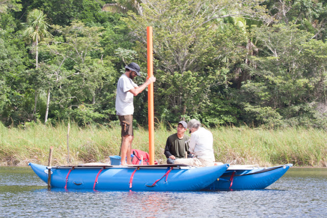
Maya more warlike than previously thought
David Wahl and Lysanna Anderson of USGS with a local assistant taking a sediment sample from the center
of Lake Ek’Naab from an inflatable platform. All the equipment had to be carried 2 kilometers down
a steep jungle trail to the lake [Credit: Francisco Estrada-Belli, Tulane]
Three other references to puluuy or "burning" are mentioned in the same war statement, referencing the cities of Komkom, known today as Buenavista del Cayo; K'an Witznal, now Ucanal; and K'inchil, location unknown. These cities may also have been decimated, if the word puluuy describes the same extreme warfare in all references. The earlier burning of Bahlam Jol/Witzna mentioned on the stela may also have left evidence in the lake cores -- there are three other prominent charcoal layers in addition to the one from 697 A.D. -- but the date of the earlier burning is unknown.

Mayan archaeologists have reconstructed some of the local history, and it's known that the conquest of Bahlam Jol/Witzna was set in motion by a queen of Naranjo, Lady 6 Sky, who was trying to reestablish her dynasty after the city-state had declined and lost all its possessions. She set her seven-year-old son, Kahk Tilew, on the throne and then began military campaigns to wipe out all the rival cities that had rebelled, Estrada-Belli said.


"The punitive campaign was recorded as being waged by her son, the king, but we know it's really her," he said.

That was not the end of Bahlam Jol/Witzna, however. The city revived, to some extent, with a reduced population, as seen in the lake cores. And the emblem glyph was found on a stela erected around 800 A.D, 100 years after the city's destruction. The city was abandoned around 1,000 A.D.

"The ability to tie geologic evidence of a devastating fire to an event noted in the epigraphic record, made possible by the relatively uncommon discovery of an ancient Maya city's emblem glyph, reflects a confluence of findings nearly unheard of in the field of geoarchaeology," Wahl said.

Author: Robert Sanders | Source: University of California - Berkeley [August 05, 2019]

The Mesoamerican attraction to magnetism


The purpose of Mesoamerican potbelly statues have been the subject of debate among anthropologists for decades: Are they depictions of the ruling elite? A way to honor dead ancestors? Or perhaps portrayals of women giving birth?

The Mesoamerican attraction to magnetism
Magnetic scans performed on potbelly sculptures from Monte Alto, Guatemala, now housed in La Democracia,
Guatemala, revealed for the first time that they were originally magnetized by lightning strikes
pre-dating the carving process [Credit: Roger Fu]
As the various theories wound their way through academic circles, the surprising discovery four decades ago that many of the statues, found in Guatemala, are magnetized in certain spots added a new dimension to those discussions.

And a Harvard study suggests that where those areas show up is no accident.

Led by Assistant Professor of Earth and Planetary Sciences Roger Fu, a team of researchers has shown that artisans carved the figures so that the magnetic areas fell at the navel or right temple—suggesting not only that Mesoamerican people were familiar with the concept of magnetism but also that they had some way of detecting the magnetized spots. The study is described in a paper published in the Journal of Archaeological Science.

"Our direct observation is that there are magnetic anomalies consistently on certain features of these sculptures," Fu said. "And the question we asked is whether this is consistent with random chance, or does it require some knowledge or some awareness of where those anomalies are?


"There's some chance it could happen randomly, but as we find more and more sculptures that are aligned like this, the smaller than likelihood is," he continued. "In this paper, we looked at four, and we found a less than 1 percent chance that this wasn't intentional."

A close study of the anomalies, Fu said, showed they could only have been caused by one source—lightning.

"All rocks contain magnetic minerals," he said. "If you go outside and pick up any random rock, it is magnetic. It's just very, very weakly magnetic. These rocks are basalts from the highlands of Guatemala, and they happen to contain quite a bit of magnetite, as well as other magnetic minerals."

Rocks typically become magnetized as they cool, and minerals like magnetite, hematite, and iron sulfides become aligned with Earth's magnetic field. While that process can create detectable magnetic fields, Fu said they are usually not even strong enough to move a compass needle.

The Mesoamerican attraction to magnetism
The sculptures may have represented people's ancestors — and showed signed
of being magnetized [Credit: Roger Fu]
The fields found in the statues, however, are far stronger—in some cases nearly four times that of the Earth's magnetic field.

"What happened here is that these rocks were struck by lightning sometime between when they were formed many thousands of years ago, and when they were carved," Fu said. "Because lightning is an electric current, it produces very strong magnetic fields, many orders of magnitude stronger than normal … and we believe the ancient Mesoamerican people were able to detect these anomalies."

It's uncertain exactly how they detected the anomalies, but earlier research had turned up evidence that Mesoamericans may have used lodestones—naturally magnetized rocks—for a variety of purposes.

"In one case, in 1975, people discovered a hematite-rich bar," Fu said. "Its purpose was unknown, and it was broken, but it was clearly very carefully made.

"If you were to tie it on a string or float it on a piece of wood, it actually could act as a compass needle," he added. "If the makers of these sculptures had access to a tool like that, that's one way they could have detected them."


And though the study suggests that ancient Mesoamerican people had knowledge of magnetism and how to detect it, it leaves unanswered the question of why the figures were carved to highlight their magnetism.

"The short answer is we don't have a good idea for the exact reason they did this," Fu said. "There are some hypotheses which are quite intriguing … that involve digging into why we think people made these sculptures.

"Probably the most successful idea is that they might represent some depiction of the ancestors of the ruling elites," he continued. "The idea is: If you have some claim to power, sculptures of your ancestors with strong magnetic anomalies could appear very impressive to your subjects. The word people use in the literature is that there's a performative aspect to these sculptures, so when the sculptures deflected a magnetized stone, it would appear as though there was something alive with it, or some supernatural aspect to it."

Ultimately, Fu said, the study offers key evidence that an understanding of magnetism existed in the Americas far earlier than first believed.

"In the Old World, there was some documentation of magnetism in the Greek world by the sixth century B.C., and the first usable compass wasn't until centuries later in China," he said. "To me, what's really interesting is this is a completely independent discovery. There's a perception that the Old World is the advanced world and transferred all this knowledge to the New one, but we are realizing that they knew a lot, and I think this is one more piece of evidence for that."

Author: Peter Reuell | Source: Harvard University [July 30, 2019]

White-tailed deer were predominant in pre-Columbian Panama feasts


In pre-Columbian times, the white-tailed deer was among the most abundant and frequently consumed mammals in Panama. It was also an icon, represented on thousands of clay vessels. Through an analysis of deer remains in refuse piles at the Sitio Sierra archaeological site, researchers from the Smithsonian Tropical Research Institute (STRI) discovered signs of "feasting behavior" associated with this animal. Their findings were published in Archaeological and Anthropological Sciences.

White-tailed deer were predominant in pre-Columbian Panama feasts
After analyzing white-deer remains from a site in Panama occupied between 2,200 and 500 years ago,
María Fernanda Martínez-Polanco found some evidence of feasting signs
[Credit: Smithsonian Tropical Research Institute]
Spanish conquistadors left some clues. They noted the abundance of deer in indigenous communities along the Pacific coast near Sitio Sierra and highlighted the existence of larders replete with dried and salted deer carcasses. These details suggest that periodic feasts may have taken place, and were likely important for enhancing social relations and strengthening alliances.

The Sitio Sierra site, a large village on the Pacific coastal plain occupied between 2,200 and 500 years ago, was excavated by STRI archaeologist Richard Cooke in the 1970s. María Fernanda Martínez-Polanco, a former pre-doctoral fellow in Cooke's lab at STRI and first author of the study, analyzed some of the evidence of feasting signs.


She found that, in certain units, remains of young white-tailed deer predominated, as well as body parts with high meat values. Most of the cut marks on the bones were due to de-fleshing, as opposed to rodent or carnivore gnawing. She also encountered the carcasses of tasty birds and mammals, a contrast from the typical food remains found around houses, consisting of marine and river fish, iguanas and small turtles.

In those units, pottery sherds were much more numerous and larger than in other contexts. A large pit with post-holes along the periphery contrasted with smaller cooking pits found in or around the structures of former houses. These findings coincide with characteristics of feasting mentioned in the scientific literature.

White-tailed deer were predominant in pre-Columbian Panama feasts
Former STRI pre-doctoral fellow María Fernanda Martínez-Polanco found that, in certain units, remains of young
white-tailed deer predominated, as well as body parts with high meat values. In those units,
pottery shards were much more numerous and larger than in other contexts
[Credit: Smithsonian Tropical Research Institute]
"This was an important tradition that could have been practiced for several generations, as we have witnessed based on the cut marks in bones, located in identical positions over different time periods," Martínez-Polanco said.

For her, the analyses of deer bone samples in conjunction with the evidence from the pottery and cooking practices, position the feasts at Sitio Sierra as part of a ritual activity. Possible motivations for feasting include ancestor worship, rites of passage, celebrations of cultural awareness and group oral-history and political gatherings designed to enhance the reputation of the provider.


Archaeologists think that Sitio Sierra was probably a low-status village, based on burials in its two cemeteries, suggesting that these feasts were likely not as sumptuous as they could have been in higher-status villages in the area, such as Sitio Conte or El Caño. Offering deer meat may have been considered a great honor for the guests and proof of the provider's status.

"Deer were more than just food for Panamanian pre-Columbian populations," Martínez-Polanco said. "Deer hunting was restricted and their consumption linked to important occasions, as we observed in the archaeological record of Sitio Sierra, allowing ancient Panamanians to share and reinforce social relations at different levels of society."

Source: Smithsonian Tropical Research Institute [July 23, 2019]

Scientists document late Pleistocene/early Holocene Mesoamerican stone tool tradition


From the perspective of Central and South America, the peopling of the New World was a complex process lasting thousands of years and involving multiple waves of Pleistocene and early Holocene period immigrants entering into the Neotropics.

Scientists document late Pleistocene/early Holocene Mesoamerican stone tool tradition
Examples of Lowe type tools recovered from Tzibte Yux (A, B) and Mayhak Cab Pek (C, D). These are among
the oldest known tools recovered from Mesoamerica [Credit: University of New Mexico]
Paleoindian colonists arrived in waves of immigrants entering the Neotropics, a region starting in the humid rainforests of southern Mexico before 13,000 years ago and brought with them technologies developed for adaptation to environments and resources found in North America.

As the ice age ended across the New World people adapted more generalized stone tools to exploit changing environments and resources. In the Neotropics these changes would have been pronounced as patchy forests and grasslands gave way to broadleaf tropical forests.


In new research published recently in PLOS One scientists from The University of New Mexico led a study in Belize to document the very earliest indigenous stone tool tradition in southern Mesoamerica.

"This is an area of research for which we have very poor data regarding early humans, though this UNM-led project is expanding our knowledge of human behavior and relationships between people in North, Central and South America," said lead author Keith Prufer, professor from The University of New Mexico's Department of Anthropology.

This research, funded by grants from the National Science Foundation and the Alphawood Foundation, focuses on understanding the Late Pleistocene human colonization of tropics in the broad context of global changes occurring at the end of the last ice age (ca. 12,000-10,000 years ago). The research suggests the tools are part of a human adaptation story in response to emerging tropical conditions in what is today called the Neotropics, a broad region south of the Isthmus of Tehuantepec (in S Mexico).

Scientists document late Pleistocene/early Holocene Mesoamerican stone tool tradition
UNM graduate student Paige Lynch conducting excavations at Mayahak Cab Pek in May 2019, part of ongoing
UNM research into the earliest humans in the New World tropics [Credit: University of New Mexico]
As part of the research, the team conducted extensive excavations at two rock shelter sites from 2014-2018. The excavation sites, located in the Bladen Nature Reserve, are almost 30 miles from the nearest road or modern human settlement in a large undisturbed rainforest that is one of the best-protected wildlife refuges in Central America.

"We have identified and established an absolute chronology for the earliest stone tool types that are indigenous to Central America," said Prufer. "These have clear antecedents with the earliest known humans in both South America and North America, but appear to show more affinity with slightly younger Late Paleoindian toolkits in the Amazon and Northern Peru than with North America."


The research represents the first endogenous Paleoindian stone tool technocomplex recovered from well-dated stratigraphic contexts for Mesoamerica. Previously designated, these artifacts share multiple features with contemporary North and South American Paleoindian tool types. Once hafted, these bifaces appear to have served multiple functions for cutting, hooking, thrusting, or throwing.

"The tools were developed at a time of technological regionalization reflecting the diverse demands of a period of pronounced environmental change and population movement," said Prufer. "Combined stratigraphic, technological, and population paleogenetic data suggests that there were strong ties between lowland neotropic regions at the onset of the Holocene."

These findings support previous UNM research suggesting strong genetic relationships between early colonists in Central and South America, following the initial dispersal of humans from Asia into the Americas via the arctic prior to 14,000 years ago.

Scientists document late Pleistocene/early Holocene Mesoamerican stone tool tradition
Early human occupation sites locations in southern Mesoamerican and South American. An inset box shows a relief
map of southern Belize of study area and the rock shelter sites [Credit: University of New Mexico]
"We are partnering with Belizean conservation NGO Ya'axche Conservation Trust in our fieldwork to promote the importance of ancient cultural resources in biodiversity and protected areas management," said Prufer. "We spend a month every year camped out with no access to electricity, internet, phone or resupplies while we conduct excavations."

This field research involves several UNM graduate students in Archaeology and Evolutionary Anthropology as well as collaborators at Exeter University (UK) and Arizona State University. The analysis for this study was done in part at UNM's Center for Stable Isotopes, as well as with co-authors at Penn State and UC Santa Barbara. At UNM this involved the new radiocarbon preparation laboratories which are part of the Center for Stable isotopes, one of the anchors of UNM's interdisciplinary PAIS research and teaching facility.


The senior co-authors are world leaders in the study of early humans in the tropics and are committed to conservation efforts of cultural resources and regional biodiversity. Additionally, Prufer's long-term collaboration in indigenous Maya communities in the region was critical to the success of this project.

"This research suggests that further exploration of links between early humans living in the neotropics are needed to better understand how knowledge and technologies were shared, and will contribute to our understanding of processes that eventually led to the development of agriculture and sedentary communities," said Prufer. "Further studies on how these tools were used for food processing will be a key aspect of this research."

Source: University of New Mexico [July 22, 2019]